


Bitterly cold out the door this morning with temperatures in the upper single digits and teens with feels like temperatures below zero in some locations.


Refreezing is expected to keep travel slick early Monday in Sussex County, and another surge of arctic air is forecast to reinforce dangerously cold temperatures through early Wednesday.


Even with the Winter Storm Warning canceled for Sussex County, wet roads could refreeze late tonight into Monday as temperatures drop back below freezing and arctic air tightens its grip on Delmarva.

A winter storm’s rain-snow changeover is easing immediate impacts in Sussex County, but wet roads could refreeze overnight and arctic air is expected to keep freezing temperatures in place through next weekend.

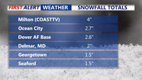
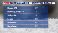
A winter storm warning remains in effect for the Delmarva Peninsula until Monday afternoon as snow spreads across Sussex County early Sunday and transitions to sleet, freezing rain and rain later in the day.


A winter storm warning remains in effect for the Delmarva Peninsula until Monday afternoon and has arrived on our doorstep at this time.


Sussex County will start Friday quiet and seasonable, but a powerful arctic blast will move in by Friday night, bringing below-zero wind chills into early Saturday morning.


A sharp blast of arctic air will bring below-zero wind chills Friday night before a weekend storm brings snow and a likely wintry mix to Sussex County.


Maryland Democrats are split on a redistricting plan that could lead to the election defeat of Andy Harris, the state's only Republican U.S. Representative.


Democrats in the Maryland General Assembly are pushing to increase the minimum wage in the state.