


DELMARVA - Temperatures climbed above freezing Sunday evening across Sussex County and Cape May County, leading to the cancellation of the Winter Storm Warning. Forecasters stressed, however, that cold air is expected to return overnight, bringing a high chance for untreated roadways to refreeze if they remain wet.
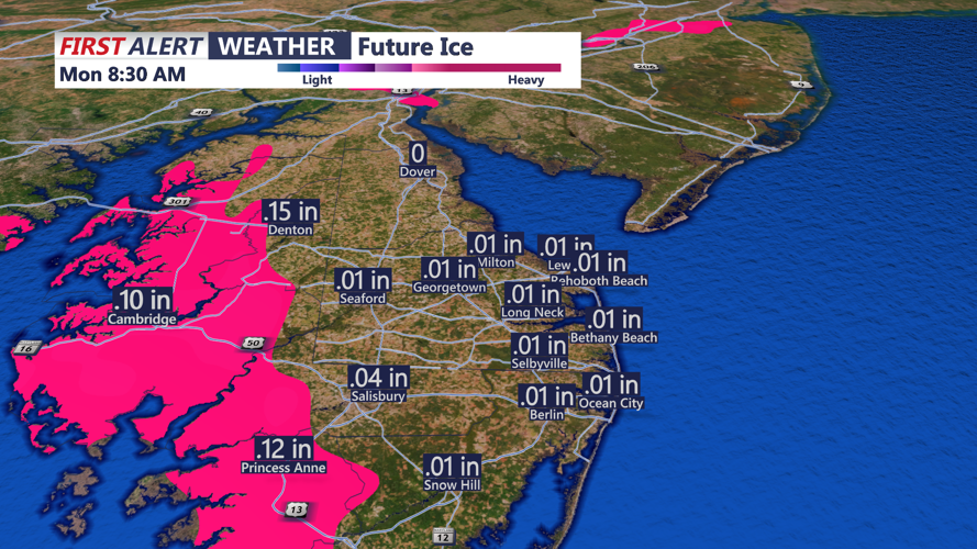
Across the region, heavy sleet and some snow continued Sunday evening, with most of the remaining snow focused north of the Delmarva area. Forecasters said a brief period of freezing rain remains possible this evening into tonight, with around a tenth of an inch of ice accretion still possible in some locations.
Precipitation is expected to taper off late tonight, some drizzle or even freezing drizzle may linger overnight. There is also a lower-confidence chance of light snow late tonight into early Monday morning, though any additional accumulation would be minor.
Even without new snowfall, travel could remain hazardous into Monday because temperatures are expected to fall into the low teens to mid-20s by Monday morning. That could leave slushy roads to harden overnight and create slick patches of black ice, especially on bridges, overpasses and untreated side roads.
The storm’s departure will not bring a quick warmup. Expect arctic air to remain in place across the region through at least next weekend, with several reinforcing shots of cold air expected during the week. High temperatures are forecast to stay mainly in the teens and 20s, with lows dropping into the single digits and potentially below zero in some areas.
Windy conditions are also expected at times, with gusts up to 30 to 35 mph possible, driving wind chill values into the single digits and teens during the day and near or below zero at night.