


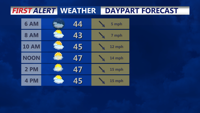
Arctic high pressure to the north will bring a mostly clear night to Delmarva with temperatures in the mid 20s by Monday morning. Wintry precipitation is possible beginning later Monday.
From
To

Patchy freezing drizzle or a brief wintry mix early Wednesday may create isolated slick spots, followed by a colder stretch with a renewed refreeze risk Wednesday night into early Thursday.

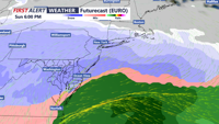
The powerful ocean storm continues to move away from the east coast with diminishing impacts.

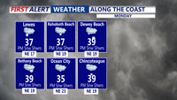
The main effects from the powerful off shore storm will be the wind, dangerous wind chills, and minor tidal flooding.

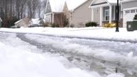
Un-plowed neighborhoods in Sussex County, Delaware, were left icy after snow and rain, forcing residents to drive and walk carefully while neighbors helped shovel, snow blow and assist one another.


Refreezing is expected to keep travel slick early Monday in Sussex County, and another surge of arctic air is forecast to reinforce dangerously cold temperatures through early Wednesday.


Even with the Winter Storm Warning canceled for Sussex County, wet roads could refreeze late tonight into Monday as temperatures drop back below freezing and arctic air tightens its grip on Delmarva.

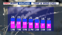
A cold early Wednesday in Sussex County rebounds to the low-to-mid 40s with sunshine, then turns chilly again overnight into early Thursday.

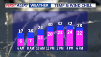
Sussex County is set for a sharp drop to around 9 degrees Tuesday night, then a sunnier, less harsh Wednesday with highs reaching the 30s and low 40s — warmest near the coast.

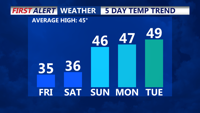
We're seeing cold conditions continuing into the first half of the weekend, with milder temperatures building in Sunday and continuing into next week.