


DELMARVA -- High pressure will begin to settle into the Central United States today, creating a strong northwest pressure gradient over Delmarva. This will lead to brisk northwest winds around 15 mph, with gusts reaching 25 to 30 mph in the afternoon. Despite the cooler airmass, temperatures are expected to climb into the mid to upper 60s, with some locations possibly reaching near 70 degrees. Dew points will drop into the upper 20s and low 30s, contributing to a dry and crisp feel in the air. So fire danger does still exist so be mindful of that.
As high pressure from the Upper Midwest approaches, the pressure gradient will weaken, allowing winds to decrease through the evening. Overnight skies will remain mostly clear, though temperatures won’t drop dramatically due to slight lingering winds. Expect lows to settle into the upper 30s to low 40s across most areas.
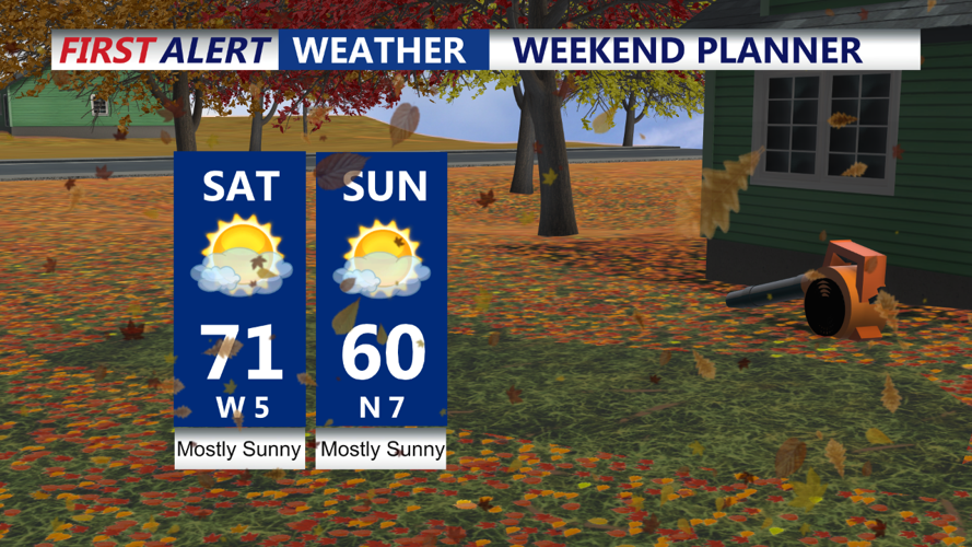
Sunday will bring the coldest temperatures of the forecast period as high pressure moves closer to Delmarva. Despite mostly sunny skies, a colder airmass will limit high temperatures to the mid to upper 50s, with some spots struggling to reach 60 degrees. It’ll be a cool and crisp autumn day, perfect for any outdoor fall activities, though a light jacket will be necessary.
With high pressure directly overhead, conditions will be ideal for radiational cooling under clear skies and calm winds. This setup will allow temperatures to plummet to near freezing in some areas, particularly in low-lying and rural spots. Widespread frost is expected across the region, and Frost Advisories may be issued for areas where the growing season remains active. Gardeners and farmers should take necessary precautions to protect any sensitive plants.
The high-pressure system will begin shifting offshore, initiating a warming trend for Delmarva. Monday will be quiet and dry with mostly sunny skies, and temperatures moderating into the low to mid 60s. By Monday night, lows will dip into the mid to upper 30s, with some spots in the low 40s, under clear skies.
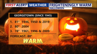
The high-pressure system will stay off the coast through the week, drawing in warmer air from the south and southwest. Temperatures will gradually rise, reaching the upper 60s to low 70s by Tuesday, and potentially hitting the upper 70s to near 80 degrees by Wednesday through Friday. Halloween could bring near-record warmth, with a forecast high of 80 degrees, just shy of the record 81°F set in 1946, 1950, and 2019. With the ground being so dry I can see us making a run at record highs.

A frontal system may approach towards the end of the week, bringing the next chance for rain and a return to more seasonal temperatures.

This potential rain could end a very dry October for Delmarva, which has seen prolonged dry conditions throughout the month.
