




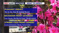
Today stays warm and sunny across Delmarva, but temperatures step down from yesterday’s record highs. Cooler air arrives near the coast Saturday as a backdoor front pushes in, while inland areas stay milder. Minor tidal flooding is expected along the Delaware coast and Delaware Bay Saturday evening into Saturday night, followed by showers, a few thunderstorms, and a sharp cool down late Saturday night into Sunday. Much colder air settles in early next week, with widespread frost or freeze conditions likely Monday night into Tuesday morning.
From
To


Delmarva will enjoy clear skies tonight as high pressure builds into the region, but brisk northwest winds and above-average temperatures will mark Saturday. Coastal flooding remains a concern along the Delaware coast through Saturday morning. Dry conditions, low humidity, and gusty winds will elevate fire risks in Delaware Saturday despite no Red Flag Warnings being issued. Looking ahead, a weak cold front will pass late Sunday into Monday without precipitation, while warmer temperatures and potential precipitation may arrive midweek with a stronger storm system.

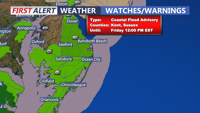
Delmarva will experience improving weather conditions today as a coastal low moves offshore. Temperatures will rise into the mid-to-upper 50s, but coastal flooding concerns will persist due to elevated tides and a full moon. Saturday ushers in sunny skies and breezy conditions with highs in the low-to-mid 60s, kicking off a stretch of above-normal temperatures through early next week.