


A surge of heat and humidity as a warm front lifts north, pushing temperatures to around 90 degrees with heat indices topping 100 in spots. Isolated storms could develop in the afternoon and evening, with a cold front stalling nearby Sunday and briefly easing humidity. Another warm front Monday will keep conditions warm and unsettled before a stronger cold front crosses the region Tuesday, bringing a renewed risk of thunderstorms. High pressure will build midweek, delivering drier and more comfortable weather.
From
To

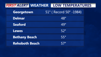
A high-pressure system currently over the Delmarva Peninsula will keep temperatures below normal through tonight, with clear and cool conditions expected. As this high pressure moves offshore into the weekend, temperatures will rebound to near-normal levels. By early next week, an approaching weather system will bring increased chances for showers and thunderstorms.