


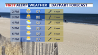


DELMARVA -- Temperatures will climb quickly into the upper 80s and near 90 degrees. Dew points will surge into the 70s, creating oppressive humidity. Heat indices are expected to exceed 100 degrees across parts of Delmarva.

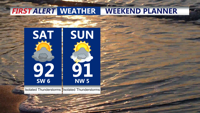
Highs in the upper 80s to low 90s, feeling like 100-105, isolated t-storms possible through the afternoon.
With the marine air mass breaking and unstable conditions building, spotty sea-breeze showers or thunderstorms may develop, severe threat has shifted northward, but downpours and gusty winds are possible where storms develop. Will stay muggy overnight under partly cloudy skies with lows in the 70s.

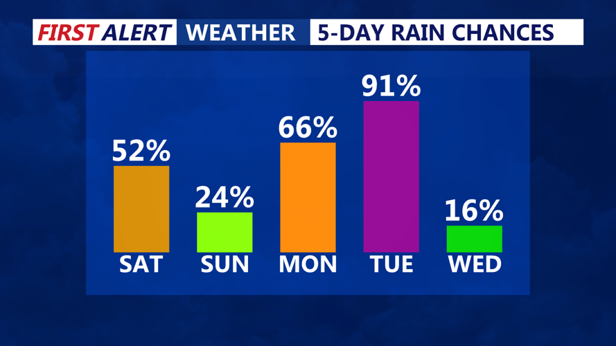
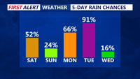
Isolated storm chances this weekend, scattered storm chances early next week.
On Sunday, the cold front will stall in the vicinity, allowing dew points to drop into the 60s across many areas. However, pockets of higher humidity could linger near the coast and southern Delmarva. Temperatures will stay warm, reaching the upper 80s to low 90s, with some triple digit heat indices possible. With less organized moisture in place, only a few isolated showers or thunderstorms are possible during the afternoon.
Humidity will climb again Monday as a warm front lifts north across Delmarva. Temperatures are forecast to approach 90 degrees, and dew points will increase, making it feel uncomfortable once more. Scattered showers and thunderstorms are possible with this front, particularly across southwestern areas, where rain chances are around 40–50 percent.
By Tuesday, an amplifying upper-level trough over the Northeast will help drive another cold front across the region. Forecasters expect enough instability and wind shear to fuel a renewed chance for thunderstorms Tuesday afternoon or evening. Some storms could be strong to severe, especially if the timing of the front aligns with peak heating. Temperatures will stay warm, with highs in the upper 80s and elevated humidity ahead of the front.
Behind Tuesday’s front, high pressure is expected to gradually build in Wednesday and Thursday. Dew points will drop into the 60s, bringing relief from the early-season heat and humidity. Temperatures will remain seasonable, generally in the 80s, with little to no rain expected midweek.
By 4th Of July, a new warm front may approach from the west, but any moisture is forecast to remain well to the west of Delmarva for now.