


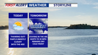
Delmarva warms up today as a warm front lifts through, pushing highs into the mid to upper 40s with partly to mostly cloudy skies. A light southerly breeze increases tonight with a small chance of a stray sprinkle, but most spots stay dry and above freezing. Wednesday stays in the 40s but turns noticeably breezy ahead of a moisture-starved cold front. Cooler, breezy conditions follow Thursday and Friday, then Valentine’s Day kicks off the weekend with sunshine and a springlike feel. Late Sunday into early Monday, a storm system could bring precipitation—details still uncertain this far out.
From
To

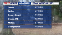
High winds continued to impact Delmarva on Sunday, bringing non-thunderstorm-related damage, including downed trees and roof damage in Laurel and Bethel, as gusts exceeded 60 mph. Peak wind speeds reached 67 mph in Lewes and Bethel, with Dewey Beach and Rehoboth Beach also experiencing strong gusts. A brief warm-up into the 60s accompanied rain, but a cold front is now bringing plunging temperatures, with lows in the 30s and wind chills in the teens and twenties by Presidents’ Day. Wind gusts of 40 to 55 mph will persist overnight. A developing coastal storm midweek could bring at least 6 inches of snow to much of Delmarva, with travel disruptions expected. The First Alert Weather team has issued Red Alerts for both the high winds and the potential winter storm.