


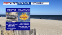
A stalled front lifting north will trigger rounds of thunderstorms across Delmarva starting Monday and lasting into Tuesday night. With temperatures climbing into the upper 80s to low 90s and abundant moisture, the atmosphere will become increasingly unstable. Forecast models point to a heightened risk of damaging wind gusts and localized flash flooding, especially Tuesday, when a Slight Risk for severe weather has been issued. Quieter and more pleasant weather is expected to settle in by midweek and continue through the Fourth of July holiday weekend.
From
To

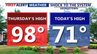
After a dramatic drop in temperatures Friday, Delmarva will swing back into heat and humidity over the weekend. A warm front lifting north will send temperatures soaring into the 90s Saturday, with heat indices over 100 degrees in spots. A weak cold front will briefly stall Sunday before more unsettled weather arrives early next week.

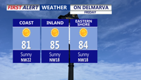
Cooler, drier air arrives early Friday in Sussex County before temperatures and humidity climb again Saturday, with a risk of isolated severe storms.

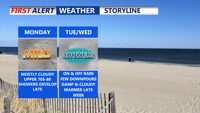
Delmarva starts the week with partial sunshine and seasonable temperatures, but a shift to wetter weather begins Monday night. Rain and occasional thunderstorms are expected through midweek, followed by another wave of unsettled conditions Friday and Saturday as back-to-back cold fronts sweep through the region.