


DELMARVA - High pressure will maintain relatively quiet and comfortable weather across the Delmarva Peninsula through Monday, but change is coming. A prolonged stretch of unsettled weather is set to move in beginning Monday night, with several rounds of showers and thunderstorms expected through the weekend.
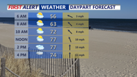
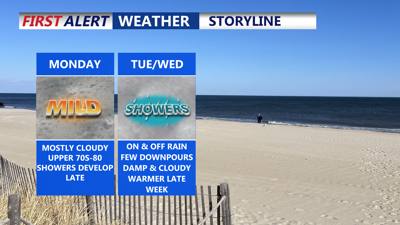
On Monday, a mix of sun and increasing high clouds, especially in the morning. Skies will gradually become overcast throughout the day, but most of the region will remain dry until after sunset. Late-day showers may clip the Maryland Eastern Shore and southern Delaware, but any measurable rain is likely to hold off for the rest of Delmarva until nighttime.
Temperatures Monday will vary by location, with inland highs ranging from 74 to 81 degrees and coastal areas topping out between 68 and 74. Winds will shift direction throughout the day—from northeasterly to southeasterly, and then southerly by afternoon—at a light 5 to 10 mph.

Temperatures rising to near 80 in some areas under mostly cloudy skies, showers move in late.
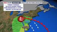
As high pressure slides eastward Monday night, a warm front will lift north through the region. This shift will usher in a low-pressure system from the southwest, gradually spreading rain across Delmarva overnight and into Tuesday.

On and off showers and downpours through midweek, steadiest rain late Tuesday-early Wednesday.
Showers are expected to be widespread through Tuesday night and linger into Wednesday. While the rain will be generally light, periods of moderate to heavy showers may occur. Rainfall totals from Monday night through Wednesday are expected to reach between a half inch to an inch, with locally higher amounts possible. The National Weather Service has issued a Marginal Risk (Level 1 of 4) for excessive rainfall, but flooding concerns remain low.
Isolated thunderstorms could develop Tuesday night, particularly over Delmarva, though the threat for severe weather is minimal. Cooler air will accompany the clouds and rain, keeping daytime highs on Tuesday and Wednesday in the upper 60s to low 70s. Overnight lows will remain relatively warm and muggy in the 50s and low 60s.
By Wednesday night, the low-pressure system begins to weaken and transition into a shortwave trough. Rain chances persist into Thursday, especially in the afternoon, when showers may become scattered again. Highs on Thursday are forecast to reach the 70s, with lows remaining mild in the low to mid-60s.
A temporary break in the rain is possible from Thursday night into Friday morning, as weak high pressure builds over the region. However, this reprieve will be short-lived. Another low-pressure system from the Great Lakes will drive cold fronts through Delmarva late Friday and again on Saturday.
These fronts will bring warmer temperatures—highs reaching into the 80s both days—as well as higher humidity, but also increase the chances for stronger thunderstorms. With more atmospheric instability expected by the weekend, we will monitor the potential for severe weather, though current signals do not indicate widespread threats.
