


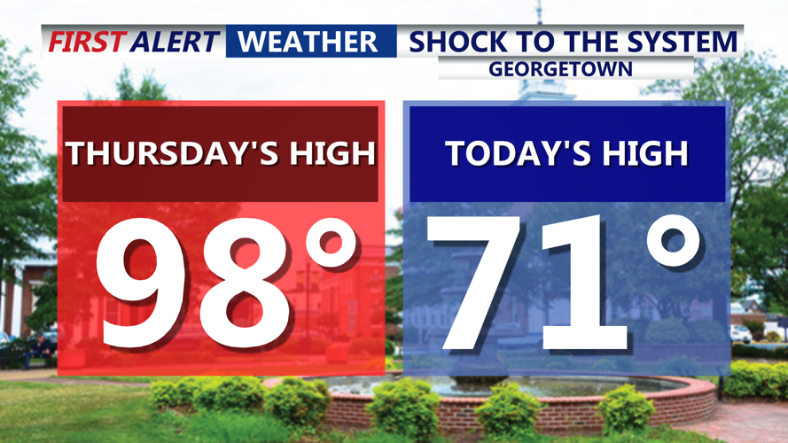


DELMARVA -- What a difference a day makes in Delmarva. After Georgetown topped out at a sweltering 98 degrees Thursday, Friday brought a sharp cooldown with a high of 71 in Georgetown. Highs across the region only reached the low 70s, thanks to a back door cold front and onshore flow delivering cooler marine air. However, this relief will be short-lived as the next surge of summer heat arrives just in time for the weekend.
Friday night will stay mostly cloudy and misty, with areas of patchy fog forming along the coast. Temperatures will hold in the low 70s overnight and gradually rise as a warm front lifts north into Delmarva. This transition sets the stage for a steamy Saturday.

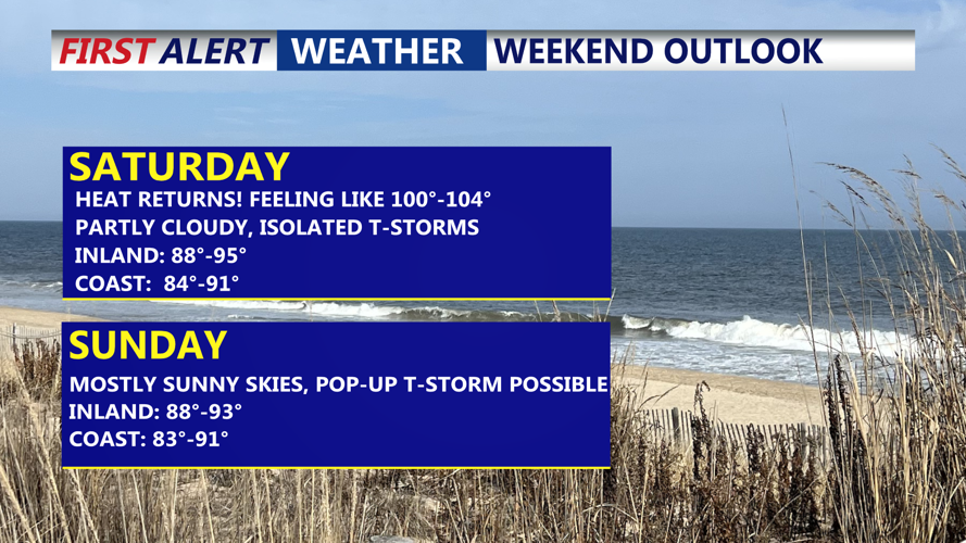
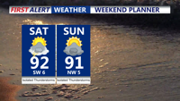
Heat and humidity return for the weekend, Saturday will feel more like 100 to 104, isolated t-storms possible.
By midday Saturday, clouds are expected to break apart, allowing for intervals of sunshine and a rapid warm-up. Highs will likely approach the low 90s inland upper 80s to low 90s at the coast, with dew points climbing well into the 70s. As a result, heat indices could exceed 100 degrees in parts of Delmarva, though they are not expected to reach the 105-degree threshold required for a heat advisory in the region.

Heat indices between 100 to 104 on Saturday away from the coast.
Isolated sea-breeze showers or thunderstorms are possible to develop in the afternoon.

Both days of the weekend highs in the low 90s, with isolated t-storms, everyone won't see rain.
The severe threat has shifted further to the north but will continue to monitor the latest.
Overnight Saturday into Sunday, the front is expected to stall near the area, allowing slightly drier air to filter in. Dew points could fall into the 60s for parts of Delmarva, though humidity may linger farther south and east. Highs on Sunday are forecast to remain in the upper 80s to low 90s, with heat indices lower than Saturday’s oppressive levels. A few showers or thunderstorms may persist, mainly where deeper moisture hangs on. Everyone won't se the rain.

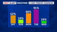
Isolated storms over the next three days, widespread t-storms with a cold front Tuesday.
The unsettled pattern will continue into early next week. A warm front is projected to lift north across the region Monday, bringing renewed chances for scattered showers and storms. High temperatures will again push toward 90 degrees, with climbing humidity.
By Tuesday, an upper-level trough will deepen over the Northeast and Mid-Atlantic, driving another cold front into Delmarva. This could set the stage for additional strong to severe thunderstorms Tuesday afternoon or evening, although exact timing and severity will depend on how instability and wind shear evolve.
Behind Tuesday’s front, slightly cooler and drier conditions are expected by midweek. High pressure should build in by Wednesday and Thursday, providing a brief period of quieter weather. Daytime highs will remain in the upper 80s to near 90, with more comfortable dew points in the 60s.