


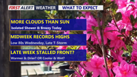
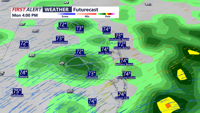
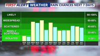
Delmarva starts the week on a warm and breezy note as a warm front lifts through the region, sending temperatures near 70 today and close to 80 Tuesday. Even warmer air builds in Wednesday, with record highs potentially challenged inland before a cold front brings the chance for afternoon and evening showers and thunderstorms. That front may stall nearby, keeping the weather unsettled through the weekend with periodic shower chances, but no day looks like a washout.
From
To

A cooler and wetter start to the week for Delmarva, then warming temperatures midweek. Hurricane Erin will remain offshore, but trigger building swells and rip current risk by early Wednesday.

Sunday will deliver more summer warmth across Delmarva with highs in the 80s and only isolated thunderstorm chances. However, a cold front approaching Sunday night will trigger scattered showers and thunderstorms into early next week, followed by additional unsettled weather as stalled fronts linger and another system nears by the weekend.

Sunday will bring another warm, humid day across Delmarva, with highs in the 80s and mostly dry skies. However, a cold front approaching Sunday night will trigger rounds of showers and thunderstorms through midweek, followed by more unsettled weather late in the week as another front arrives.