


DELMARVA -- Sunday will bring another warm and humid day across Delmarva, resembling Saturday’s weather almost to the degree.

Mix of sun and clouds, isolated storm possible on the Eastern Shore.
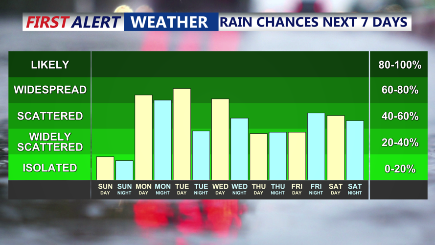
Temperatures will climb into the low to mid-80s along the coast and reach the mid to upper 80s inland. While most communities will stay dry, an isolated storm could develop over parts of the Eastern Shore by late afternoon. However, the better chances for showers will remain well to the north and west through the day.
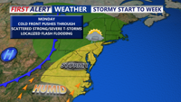
Sunday night marks the start of a more unsettled pattern as a slow-moving cold front approaches from the west. Showers and thunderstorms are expected to develop overnight, especially across western areas. The front will advance only gradually into Monday, with spotty rain possible during the morning commute depending on how quickly the system progresses.
By Monday afternoon and night, the front will continue to sag toward the coast, bringing another round of showers and thunderstorms. Humid conditions will persist, and temperatures will hold near seasonable levels, with daytime highs staying in the 80s.

Cold front pushes through Monday, bringing with it the threat of scattered showers and storms.
Tuesday will offer a slight reduction in rain chances, but the front is expected to stall in the region. Even if much of the day remains dry, scattered showers or thunderstorms could redevelop in the afternoon, particularly where daytime heating and lingering moisture combine.
Fog formation is also possible overnight and into early morning hours throughout this period, especially in areas that receive rain and experience lighter winds.
Looking toward midweek, the pattern is not expected to improve significantly. The stationary boundary will linger over or near Delmarva through Wednesday before lifting back north as a weak warm front Wednesday night into Thursday. This setup will keep daily chances for showers and thunderstorms in place, mainly during the afternoon and evening hours.
Another cold front is forecast to approach the region late Friday into Saturday. This system could deliver additional rounds of storms, and forecasters will monitor its progress closely to assess any severe weather risk.