


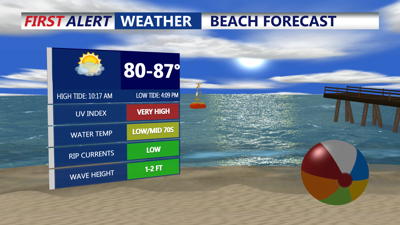
DELMARVA -- Sunday will feel almost identical to Saturday across Delmarva, as warm, muggy air holds its grip on the region. Highs will reach the low to mid-80s along the coast and climb into the mid to upper 80s inland. While a stray storm could bubble up over parts of the Eastern Shore during the afternoon, most areas will remain dry, with any significant showers staying to the north and west.

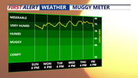
Staying in the very humid range into most of next week, despite a cold front passing through Monday.
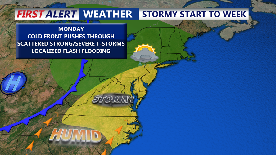
The calm will start to fade Sunday night as a cold front approaches from the west. Showers and thunderstorms are expected to develop overnight, particularly across the western half of the region. By Monday morning, spotty rain could linger depending on the pace of the front’s arrival.

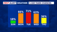
Scattered showers and storms Monday afternoon-evening, front may stall over the area into midweek.
Expect the front to drift only slowly southeast through Monday into Tuesday, keeping conditions unsettled. Monday afternoon and night could see another round of showers and thunderstorms as the boundary sags across the area.

Cold front Monday brings renewed chances for scattered showers and storms.
Tuesday offers a slight break in precipitation chances, but with the front stalling overhead, scattered showers or storms could redevelop in the afternoon. Fog may form overnight into early morning hours during this stretch, especially where rain has fallen and winds are light.
The unsettled pattern is forecast to persist into late week. By Wednesday and Thursday, the stalled boundary is expected to lift back north as a weak warm front, reigniting chances for scattered thunderstorms mainly in the afternoon and evening. Heat and humidity will continue to build, and heat indices could once again climb above 100 degrees Wednesday through Friday.
By Friday and into early Saturday, another cold front is projected to approach the region. This system could bring additional showers and storms as it passes, though exact timing and severity remain uncertain.