


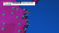
Sussex County will see rising temperatures and humidity through Friday, with dangerous heat and evening storm chances before relief arrives late Friday night.
From
To

Dry high pressure will keep the Delmarva region sunny and seasonable through Saturday, with warmer and stormier weather expected to return early next week.


Thursday brings one final day of 90-degree heat to Delmarva before a backdoor cold front moves in, sparking chances for gusty thunderstorms and ushering in cooler conditions. Though the risk of severe storms is low, isolated damaging wind events and downpours are possible. A brief cool spell follows on Friday, but the weekend and early next week feature unsettled weather and a return to above-normal temperatures.. A brief cool spell follows on Friday, but the weekend and early next week feature unsettled weather and a return to above-normal temperatures.

Delmarva faces a marginal risk for severe storms Sunday afternoon and evening as a frontal boundary stalls over the region. Showers and thunderstorms—some potentially strong with damaging winds and isolated tornadoes—could impact parts of the peninsula, especially the southwest. Quieter weather returns Monday before another round of rain and storms arrives Tuesday. The second half of the week turns drier and significantly warmer, with highs reaching the 80s and possibly nearing 90.