


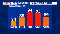

DELMARVA - A warm, calm start is expected for Sussex County early Thursday morning as high pressure continues to influence the region. Temperatures will begin the day in the 60s inland and low 70s along the coast under mostly clear skies.
Thursday will feature plenty of sunshine and rising warmth as southerly winds draw in more humidity. Afternoon highs are forecast to reach the upper 80s to near 90 degrees, with comfortable conditions compared to what lies ahead. Thursday night will remain warm and increasingly muggy, with lows in the upper 60s to low 70s.
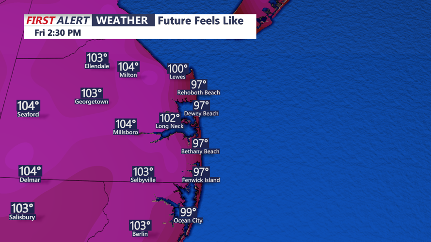
By Friday, hot and humid conditions take hold, pushing afternoon highs into the mid-90s. Dew points in the low to mid-70s will drive heat indices to around 100–107 degrees, prompting heat advisories across the area. Residents are urged to limit outdoor activity and stay hydrated.
As a cold front approaches Friday evening, isolated to scattered thunderstorms may develop. Some storms could become strong to severe, with damaging wind gusts as the primary hazard. The front will begin to settle over the region by early Saturday morning, bringing an end to the extreme heat but ushering in unsettled conditions for the weekend.