


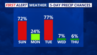


DELMARVA -- A warm front continues its slow northward progression. The stalled front, combined with a passing disturbance aloft and multiple rounds of mesoscale convective vortices (MCVs), creates the potential for scattered showers and thunderstorms between 3 p.m. and 10 p.m.. However confidence isn't that high on how far north the storms get.

Cloudy humid conditions with showers late morning, another round of potential severe storms is possible late afternoon-evening.
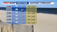
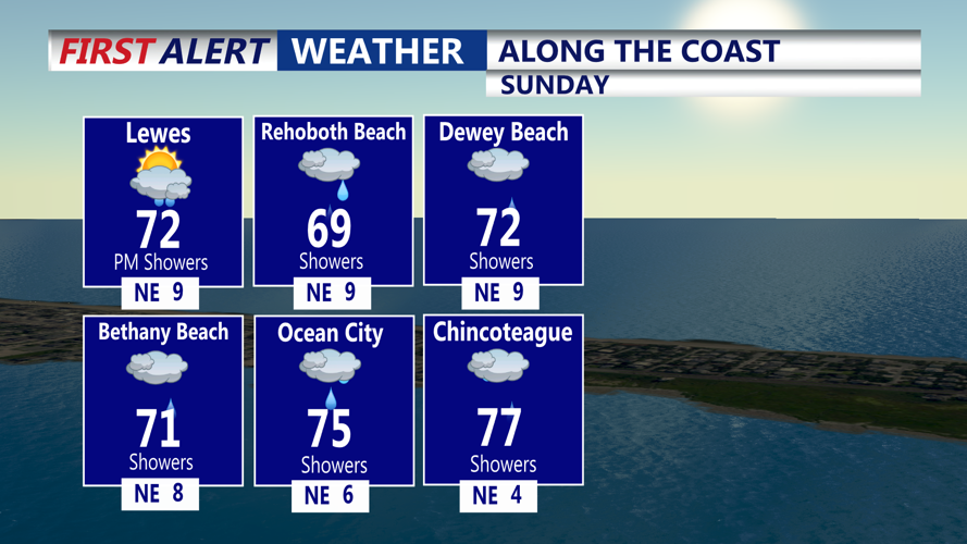
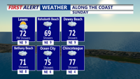
While confidence in the exact timing and location of severe weather remains low, the southwestern portion of the peninsula—closer to the core of instability—faces the greatest risk for strong storms. The region as a whole sits on the northern edge of a broader severe risk zone, with Delmarva forecasted to remain mostly cloudy through the day, and afternoon highs ranging from the upper 60s to mid-70s.

Dry out Monday before another cold front brings scattered showers and thunderstorm chances.
Main threats include damaging wind gusts, with hail and an isolated tornado also possible, particularly near the warm front where surface winds may briefly back and enhance low-level rotation.
Showers and thunderstorms are expected to taper off Sunday night, especially after midnight. Skies remain mostly cloudy with overnight lows dipping into the low 60s as high pressure begins to build from the north.
Most of Delmarva will enjoy dry and calm conditions Monday, thanks to that building high pressure. Temperatures will climb into the low to mid-70s, with a slightly muggy feel sticking around. Skies remain mostly cloudy, and overnight lows fall again into the low to mid-60s.
The break in active weather is short-lived. A new area of low pressure riding along the same frontal boundary will move through the region Tuesday. Latest guidance shows precipitation beginning in the morning and continuing into early afternoon, with showers likely and thunderstorms possible.
Though widespread severe weather is not anticipated at this time, wet and muggy conditions will dominate the day, with highs in the 70s. The front clears the region Tuesday night, finally pushing offshore.
Starting Wednesday, a more summerlike pattern emerges. A ridge of high pressure to the southwest brings in a warm west-southwesterly flow, allowing temperatures to surge into the low to mid-80s midweek. By Thursday and Friday, inland and urban areas could flirt with the 90-degree mark.
Skies remain dry and mostly clear through Friday, though a weak front may dip into the area Friday night into Saturday, possibly triggering a few showers or thunderstorms and nudging temperatures back to more seasonable levels for the weekend.
