


DELMARVA - Due to a combination of low relative humidity values between 20 and 30 percent, northwest winds around 10-15 mph (gusting up to 20 mph), and drying fuels, the potential for the spread of fires today has increased. Residents are urged to exercise caution with potential ignition sources, including machinery, cigarettes, and matches. Proper disposal of all smoking materials is essential as any dry grasses and tree litter that ignite could spread quickly.
High pressure will extend eastward from the Midwest to the Mid-Atlantic, building towards the East Coast through Tuesday. A cold front is expected to move through the region on Wednesday, followed by another high-pressure system pushing southeastward from the Great Lakes on Thursday and Friday. An approaching warm front may bring some rain over the weekend.
THROUGH TUESDAY/...
High pressure originating from the southern states tonight will spread across the East Coast and Mid-Atlantic region through Tuesday. The area will continue to experience quiet weather conditions with mostly clear skies and breezy conditions persisting into the afternoon. Occasional cumulus clouds or high-level cirrus may appear later today, with wind speeds reaching 15-20 mph.
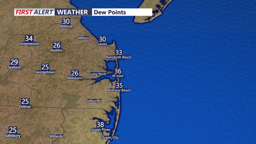
A steady northwest flow will facilitate sufficient mixing and drying this afternoon. With temperatures expected in the low to mid-60s and dewpoints in the 20s, conditions near the coast will be cooler due to seabreeze effects. The dry and warm weather will heighten fire concerns; refer to the Fire Weather section for more details.
Tonight, as the ridge axis elongates and positions overhead, clear skies will prevail. Another round of patchy frost is anticipated in areas that experienced similar conditions this morning due to optimal radiational cooling. A new Frost Advisory has been issued for tonight covering portions of eastern Pennsylvania and central and eastern New Jersey. Temperatures will drop primarily to the 30s, with coastal areas experiencing lows in the 40s.