



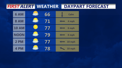

DELMARVA- A ridge axis will slide overhead, with high pressure in control at the surface. Expect a nice and quiet day overall. Due to the weak onshore flow, coastal areas will remain in the 70s, while inland regions will see temperatures in the low to mid-80s.
An upper-level ridge over the area Tuesday night will flatten out on Wednesday. Meanwhile, a nearly vertically stacked area of low pressure over central Canada will dig down into the upper Midwest and Great Lakes. A trough will develop out ahead of this system, leading to weak surface low pressure forming over the Mid-Atlantic and Delmarva.
Scattered showers and thunderstorms are expected to develop by Wednesday afternoon, with showers becoming likely late in the day for the eastern shores of Maryland. Dew points will rise well into the 60s, which could result in locally heavy downpours in the afternoon.
Low pressure will then move over the area Wednesday night, departing by Thursday afternoon. During this time, we will carry a likely probability of precipitation for the region. There may be enough instability for thunderstorms as well, so there is a continued chance for thunderstorms.
Highs will be in the lower 80s on both Wednesday and Thursday, though Thursday may be a degree or two warmer, depending on when the rain ends and skies clear out. Expect fairly humid conditions with dew points well into the 60s.
