



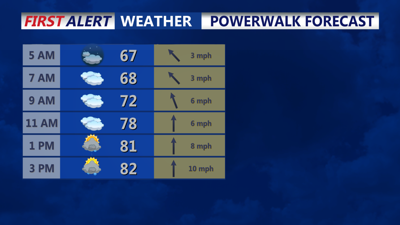

DELMARVA - Wednesday begins a stretch of unsettled weather that will last into the weekend as an upper-level low moves into the Great Lakes region, where it will meander through about Saturday. A warm front will be positioned just to our south and west, lifting north on Wednesday afternoon, evening. A subtle shortwave will move through Wednesday afternoon, bringing showers and thunderstorms. The best chance to see thunderstorms and heavy rain will be over the Delmarva peninsula.
While heavy rain is likely Wednesday for some locations, the flash flooding threat is low as storm motion should be steady and training/back building is not expected. The threat increases Wednesday night into Thursday. Temperatures will reach the upper 70s to low 80s tomorrow. The upper-level ridge will remain over the area on Wednesday before flattening out by Wednesday night.
At the same time, a deep upper trough will be accompanied by a nearly vertically stacked low-pressure system meandering around southern Canada and the northern Great Lakes during the period. A subtle shortwave will eject east ahead of the parent trough on Wednesday night into Thursday, resulting in a warm front lifting north across the area Wednesday night and a cold front passing through by Thursday night.
