


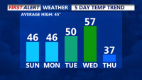
High pressure over the Southeast will bring seasonable temperatures and mostly dry conditions to Delmarva starting today. Temperatures will rise into the 50s by midweek as a January thaw sets in, but a stronger cold front late Wednesday will bring colder air by the week's end. Winds will gust up to 25 mph today, with highs in the mid to upper 40s. A brief dip in temperatures follows Thursday and Friday, with highs in the 20s and 30s before moderating slightly by Saturday.
From
To

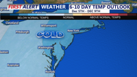
A weak low-pressure system may bring light precipitation Sunday night, while Monday features clearing skies with chilly conditions as high pressure begins to influence Delmarva.

Above-normal temperatures kick off the week, but all attention turns to a potential storm system impacting the region on Thanksgiving and into Friday. Rain is favored for most areas, followed by colder air and brisk conditions into the weekend.

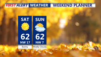
Delmarva will enjoy clear skies tonight as high pressure builds into the region, but brisk northwest winds and above-average temperatures will mark Saturday. Coastal flooding remains a concern along the Delaware coast through Saturday morning. Dry conditions, low humidity, and gusty winds will elevate fire risks in Delaware Saturday despite no Red Flag Warnings being issued. Looking ahead, a weak cold front will pass late Sunday into Monday without precipitation, while warmer temperatures and potential precipitation may arrive midweek with a stronger storm system.