


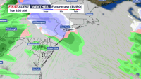
High pressure brings a cold, calm start to Monday in Sussex County before clouds thicken overnight and a weak system approaches early Tuesday.
From
To

A ridge of high pressure will keep Delmarva dry and mild through Monday, with warmer temperatures on the way as a southerly flow develops. Highs will reach the low to mid-60s, making for a pleasant start to the week, but changes are ahead with a cold front arriving midweek.

High pressure will maintain clear, dry, and sunny conditions across the Delmarva Peninsula through the beginning of the week. Expect seasonable temperatures on Sunday before a warming trend takes hold on Monday and Election Day. A weak cold front moving through midweek could bring some clouds and a slight chance of drizzle, with a return to cooler temperatures by Friday.


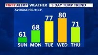
A cool and breezy weekend as high pressure builds over the region. Today will bring gusty northwest winds, with temperatures peaking in the upper 60s to near 70 degrees. A colder air mass moves in by Sunday, with daytime highs struggling to reach 60 degrees and widespread frost likely by Sunday night. The upcoming week will see a warming trend, with temperatures potentially reaching near-record highs by midweek under continued dry conditions.