





Today stays warm and sunny across Delmarva, but temperatures step down from yesterday’s record highs. Cooler air arrives near the coast Saturday as a backdoor front pushes in, while inland areas stay milder. Minor tidal flooding is expected along the Delaware coast and Delaware Bay Saturday evening into Saturday night, followed by showers, a few thunderstorms, and a sharp cool down late Saturday night into Sunday. Much colder air settles in early next week, with widespread frost or freeze conditions likely Monday night into Tuesday morning.
From
To

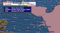
Low clouds and patchy fog linger late Friday as small-craft conditions continue offshore, then Saturday turns calmer and milder — a short window to get ready for a wintry, windy system set to arrive Sunday into Monday.

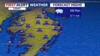
After morning rain temperatures bounce back nicely this afternoon into the 50s to near 60 across Delmarva with a mix of sun and clouds. A coastal storm brings rain, snow, and wind late in the weekend.

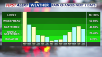
A developing coastal storm is bringing periods of rain and gusty winds to Delmarva beginning Wednesday afternoon, with temperatures stuck in the 50s. The unsettled pattern continues into Thursday before tapering into scattered showers Friday. A gradual clearing trend and slightly warmer weather is expected over the weekend, though cooler-than-average temperatures persist.