


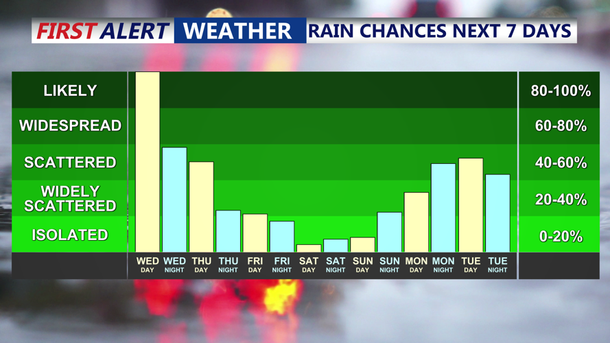


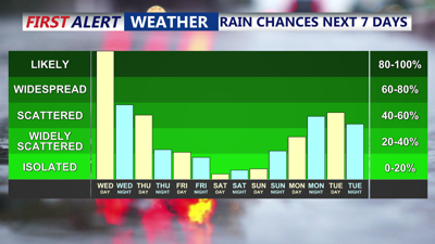
DELMARVA -- We have a Yellow Alert in place for the threat of heavy rainfall and wind. A pair of low pressure systems is setting the stage for a soggy and chilly midweek stretch across Delmarva, beginning Wednesday afternoon.
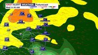
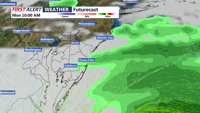
Rain associated with a weakening low in the Ohio Valley and a developing coastal low off the Mid-Atlantic is steadily expanding into the region. The initial rain will be light, with breaks and patchy drizzle, particularly in southern areas, before steadier precipitation returns by evening. This pattern may evolve into more showery conditions through the day.

Rain heavy at times through Wednesday afternoon.
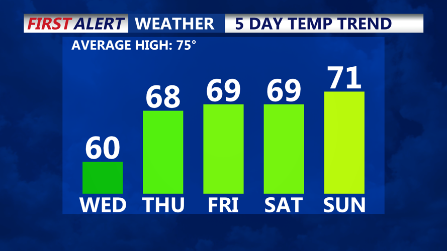
Temperatures Wednesday are struggling to climb, with highs not expected to leave the 50s due to persistent cloud cover, onshore flow, and periods of rain.
By tonight, the surface low consolidating near the coast will track northward off the New Jersey coast, drawing in a low-level easterly jet that may enhance rainfall across the area. Some heavier downpours are possible, with localized urban flooding not out of the question. Rainfall totals of 1 to 1.5 inches are expected through Thursday.

Below average temperatures persist into the weekend.
Winds will also increase this evening into Thursday morning, with gusts of 25 to 35 mph likely, especially along the coast. These winds shift from the east to the north and northwest by Thursday as the storm pulls away, which may bring a slight decrease in gust intensity.
While rain continues Thursday, it should become more intermittent and scattered as the day progresses. Temperatures may recover modestly, with the potential for highs reaching into the 60s across Delmarva and parts of southern New Jersey where precipitation is lighter and some breaks in the clouds may occur.
By Thursday night into Friday, the main storm energy shifts into the Gulf of Maine and northeastern U.S. Although rain will taper, lingering upper-level energy could produce isolated to scattered showers Friday, with only light rainfall expected. Highs will remain seasonably cool in the 60s.
Looking ahead to the Memorial Day Weekend, high pressure attempts to build from the west, bringing drier and gradually milder weather. Highs will climb into the 60s on Saturday and possibly the low 70s by Sunday, though the risk of a stray shower cannot be ruled out.

A pesky area of low pressure could bring clouds and showers for Memorial Day.
By early next week, forecasters are watching a new low developing along the Gulf Coast. While its eventual track remains uncertain, it could brush Delmarva with renewed rain chances by Monday or Tuesday, depending on how far north the system moves.


