




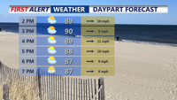
Sunday will be hot and humid across Delmarva with temperatures rising into the upper 80s and low 90s and heat index values between 100 and 104 degrees. A cold front approaching from the northwest could trigger isolated storms late in the day, some of which may become severe. After the front moves through, high pressure will bring more comfortable and dry conditions through Wednesday before heat and humidity return late in the week.
From
To


A surge of heat and humidity as a warm front lifts north, pushing temperatures to around 90 degrees with heat indices topping 100 in spots. Isolated storms could develop in the afternoon and evening, with a cold front stalling nearby Sunday and briefly easing humidity. Another warm front Monday will keep conditions warm and unsettled before a stronger cold front crosses the region Tuesday, bringing a renewed risk of thunderstorms. High pressure will build midweek, delivering drier and more comfortable weather.


Rain and downpours return to Delmarva Sunday with a stretch of unsettled weather lasting into Tuesday as multiple waves of energy track through the region. While conditions briefly dry out by midweek, another cold front and upper-level system will bring more showers and cooler temperatures before the weekend.

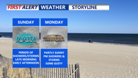
Scattered showers and storms with highs in the low to mid 70s Sunday. A mild, humid weekend transitions into a wet and cooler start to the workweek across Delmarva, with periods of heavy rain and thunderstorms expected through Tuesday. A cooler, more stable pattern begins to emerge by the end of the week.

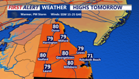
A surge of warm, humid air will usher in showers and a chance for storms across Sussex County, the Delaware Beaches, and Ocean City from late Wednesday into Thursday night, with temperatures climbing well into the 70s before a cold front cools things down.