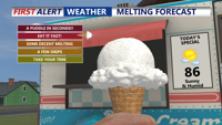
Locals and visitors in Rehoboth Beach are taking the heat in stride, by following simple tips to staying safe in the excessive heat.
Locals and visitors in Rehoboth Beach are taking the heat in stride, by following simple tips to staying safe in the excessive heat.
Scorching heat continues early Wednesday in Sussex County, but a cold front is expected to bring relief, scattered storms, and cooler temperatures by Friday.

Will experience an early arrival of showers and storms due to a progressing cold front and upper-level trough. This shift will mitigate excessive heat and severe weather risks but may lead to heavy rain and flash flooding in some areas. By Sunday night, rain and storms will move offshore, giving way to high pressure and mostly sunny skies on Monday. The long-term forecast suggests active weather midweek due to another cold front and a tropical system in the southeastern US.
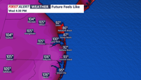
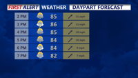
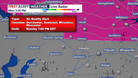
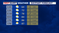
Hot and humid conditions continue tonight with thunderstorms tapering off and patchy fog likely along the coasts. Tomorrow morning brings even more oppressive heat with dangerous heat indices and an air quality warning in effect until 11 PM EDT tonight.
A cold front moving offshore brings cool and dry conditions to Delmarva tonight, with high pressure maintaining fair weather through Tuesday.
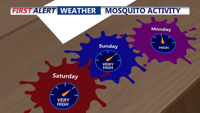
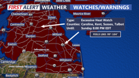
A Heat Watch has been issued for Delmarva, with temperatures expected to soar on Saturday and early Sunday, prompting safety precautions to prevent heat-related illnesses.

With all of Delaware under a heat advisory or excessive heat watch alert from the National Weather Service, the Delaware Division of Public Health (DPH) has issued information and tips to help people stay safe during this weekend's heat wave and throughout the summer.

The first full day of summer is a hot one for Delmarva, and it gets even hotter this weekend, with excessive heat possible.
Delmarva will experience rising temperatures and humidity on Friday, with a chance of showers and thunderstorms in the afternoon and evening.
Tonight brings cooler temperatures with clear skies, while tomorrow will be hot but less humid, triggering a Heat Advisory.