


DELMARVA-- Will experience an early arrival of showers and storms due to a progressing cold front and upper-level trough. This shift will mitigate excessive heat and severe weather risks but may lead to heavy rain and flash flooding in some areas. By Sunday night, rain and storms will move offshore, giving way to high pressure and mostly sunny skies on Monday. The long-term forecast suggests active weather midweek due to another cold front and Tropical Storm Debby.
Delmarva will see a change in weather on Sunday as a surface cold front and mid to upper-level trough move eastward through the region. This progression will bring showers and thunderstorms earlier in the day compared to the previous days. The early timing of these storms means that excessive heat is not a significant concern. However, heavy rain and potential flash flooding remain possible, especially in areas that received substantial rainfall on Saturday.
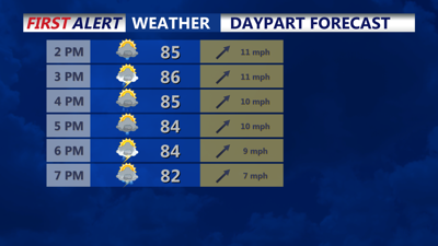
By Sunday night, the cold front will continue its passage through Delmarva, with lingering showers and thunderstorms shifting towards the coast. All convective activity should be offshore by midnight. Patchy fog may develop overnight, particularly in areas that experienced rainfall during the day. Temperatures will range from the upper 60s to mid-70s.
High pressure will begin to build from the west on Monday, bringing mostly sunny skies and warmer temperatures, with highs rebounding to the low to mid-90s, heat indices will be in the triple digits away from the coast. High pressure will start to move out by Monday night, leading to increasing clouds and higher humidity levels, with lows in the upper 60s to mid-70s, making it feel quite warm and muggy.
The long-term forecast for Delmarva indicates an active weather pattern influenced by high pressure to the north and Tropical Storm Debby to the south. On Tuesday, a low-pressure system tracking north of the region will bring a cold front, causing scattered thunderstorms from late afternoon to early evening. This front should clear the area by Wednesday, stalling nearby as high pressure builds to the north.
Attention then turns to the tropical system in the southeastern US. The interaction between the high pressure to the north and the tropical system will play a crucial role in the weather. Current models suggest that the high pressure will block the tropical system from moving out to sea, leading to the potential for tropical moisture and multiple rounds of precipitation from Wednesday through Saturday. More specific impacts and the evolution of the system will become clearer early next week.
Temperatures are expected to be near-normal on Tuesday before dropping below-normal towards the end of the week. Residents should stay updated with the latest forecasts as the weather situation evolves.
