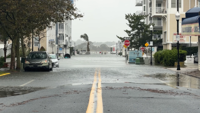
Police say floodwaters are expected to take several hours to recede, meaning roads could remain impacted well after the tide falls.
Police say floodwaters are expected to take several hours to recede, meaning roads could remain impacted well after the tide falls.
Wicomico Street in Ocean City experiencing high tide, with a clear look at S Philadelphia Ave inundated.
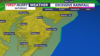
The heavy rain threat continues this afternoon and evening. Some isolated flash flooding is possible.
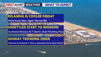
Delmarva gets a brief break from storms today before another round of heavy rain raises the risk of flash flooding Saturday.
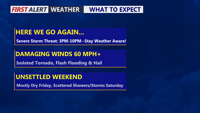
Delmarva faces a potentially active weather day as a strong cold front brings widespread showers and thunderstorms to the peninsula. Damaging wind gusts, flash flooding and a few tornadoes are possible late this afternoon and evening, with some areas potentially receiving several inches of rain. Unsettled weather will continue through the weekend before drier conditions return early next week.
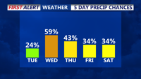
Cloudy conditions and scattered showers will dominate the weather pattern across Delmarva on Tuesday, with temperatures remaining mild. Rain chances will increase late Tuesday into Wednesday as tropical moisture associated with the remnants of Potential Tropical Cyclone 8 and a coastal low move into the region. Unsettled weather is expected to continue into Thursday with the possibility of heavy rain, although flood risk remains low due to recent dry conditions. Temperatures will stay in the 70s during the day and 60s at night throughout the week.
A slight chance of scattered showers will develop across Delmarva tonight, with increasing precipitation chances moving northward through Tuesday. Low temperatures tonight will be mild, staying in the upper 60s. On Tuesday, the cloudy and mild conditions will persist, with highs reaching the mid to upper 70s. Northeast to east winds around 10 mph will continue. As we move into Wednesday, the remnants of Potential Tropical Cyclone 8 and a secondary coastal low could bring periods of heavy rain, although the track of these systems remains uncertain.