


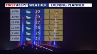
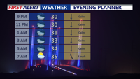
Conditions remain dry into the evening, with partly cloudy skies and overnight lows dropping into the low to mid 20s by Saturday morning.
From
To

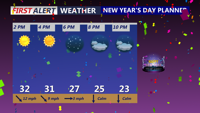
The new year is off to a very cold and windy start with feels like temperatures in the teens and 20s into the weekend.

A cloudier end to the weekend with Sunday showers, then a coastal low brings a cold rain on Tuesday with a Yellow Alert.

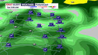
Developing area of low pressure passing offshore late tonight will bring periods of light rain to begin the weekend, then a drier Sunday.


DELMARVA - A mild and dry start to the weekend with slight shower chances. Then windy and turning colder Sunday into early next week.

A cold front will slide southeast through the region this evening, but it’s expected to pass without rain and with little added cloud cover. The main change will be a noticeable uptick in winds and a refreshing push of cooler air.

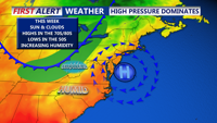
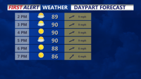
High pressure will dominate the region into early Thursday, keeping conditions dry and pleasant. Daytime highs will top out in the upper 70s and 80s, while overnight lows fall into the 50s and 60s.

A pleasant stretch of late-summer weather continues today, but beachgoers are being warned of dangerous conditions in the surf with a high risk of rip currents.

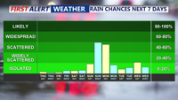
For today through Saturday night, a stalled front will weaken further. With less forcing aloft and only modest afternoon heating, thunderstorms should become more isolated to scattered and mainly develop inland, away from the cooler marine influence.

Wednesday brings scattered showers and thunderstorms to Delmarva as a shortwave trough passes through, while temperatures climb into the 90s. The trend towards drier and hotter weather continues into the weekend, with potential heat advisories.