


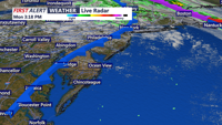
Sussex County will see brief calm weather Monday night before a cold front arrives Tuesday night, bringing showers, gusty winds and a midweek cooldown.
From
To

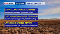
Delmarva will see a stretch of dry and mild weather beginning Monday, with sunshine and highs in the low to mid-60s inland and 50s along the coast. Southwest winds will push temperatures even higher Tuesday before a midweek cooldown. A backdoor cold front will briefly lower temperatures Wednesday before shifting north again, allowing a warming trend into the weekend. Highs could reach the low 70s by Saturday, with rain chances returning Sunday night.

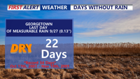
A prolonged dry spell continues across Delmarva as a warming trend sets in through the weekend and early next week. Today temperatures will reach the mid-to-upper 70s under clear skies, with slightly higher humidity. By early next week, temperatures could approach near-record highs in the low 80s, though coastal areas may remain cooler. While a cold front midweek brings a brief cooldown, significant rainfall remains unlikely, extending the already notable dry streak.

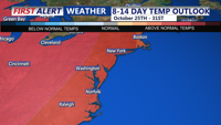
High pressure will dominate Delmarva’s weather through the weekend and into the early part of next week, delivering clear skies and above-normal temperatures. Expect pleasant fall conditions with daytime highs in the low to mid-70s on Saturday and Sunday. A warming trend will peak Monday with highs near 80 degrees before a cold front moves through midweek, bringing cooler, more seasonable temperatures, though little to no rain is expected.