


Spring fever continues across Delmarva as high pressure over the western Atlantic brings sunny skies, highs in the 70s inland, and even a few spots near 80. Beach communities should turn sunnier with highs in the 60s before fog returns tonight. Wednesday will be the last very warm day before a strong cold front arrives with gusty winds and the chance for a few strong to severe thunderstorms Wednesday evening, followed by sharply cooler air.
From
To


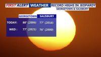
Warm and mostly dry conditions will persist through Wednesday on Delmarva, with near-record high temperatures possible. A cold front will move into the area late Wednesday night, bringing cooler temperatures and a chance of showers by Thursday.

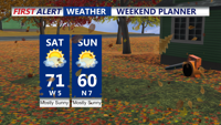
A cool and breezy weekend as high pressure builds over the region. Today will bring gusty northwest winds, with temperatures peaking in the upper 60s to near 70 degrees. A colder air mass moves in by Sunday, with daytime highs struggling to reach 60 degrees and widespread frost likely by Sunday night. The upcoming week will see a warming trend, with temperatures potentially reaching near-record highs by midweek under continued dry conditions.

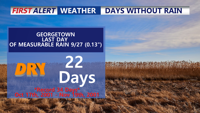
A prolonged dry spell continues across Delmarva as a warming trend sets in through the weekend and early next week. Today temperatures will reach the mid-to-upper 70s under clear skies, with slightly higher humidity. By early next week, temperatures could approach near-record highs in the low 80s, though coastal areas may remain cooler. While a cold front midweek brings a brief cooldown, significant rainfall remains unlikely, extending the already notable dry streak.