


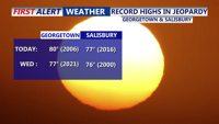
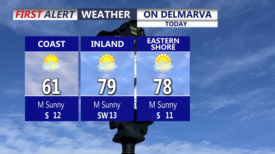


DELMARVA -- Spring fever continues across Delmarva as high pressure over the western Atlantic stays in control. Inland areas will climb well into the 70s this afternoon, and a few spots could even touch 80 degrees. Georgetown and Salisbury may come close to record highs over the next two days. Along the beaches, the marine layer that lingered yesterday should move offshore, allowing for sunnier skies and highs in the 60s from Ocean City to Fenwick Island and Dewey Beach.

Warming up nicely on the peninsula, still cooler along the bay and ocean.
Tonight will stay very mild as humidity begins to increase. Fog is expected to redevelop this evening and last into early Wednesday morning, with overnight lows only falling into the mid to upper 50s. Georgetown could even challenge its record warm low of 55 degrees, set in 1955 and again in 1986.
Wednesday will be the last day of the unusual warmth across Delmarva before a strong cold front moves in. Highs will once again reach the mid to upper 70s inland, with cooler conditions near the coast. Skies will turn partly sunny as clouds build during the afternoon, and south winds will strengthen with gusts of 30 to 35 mph.
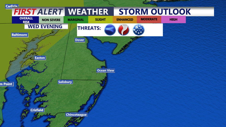
There is also a risk for a few strong storms Wednesday evening. The Storm Prediction Center has placed parts of the region under a marginal risk, level 1 out of 5, for isolated severe weather.

Storm Prediction Center has the area placed under a "marginal" risk (1 out of 5), an isolated severe storm is possible Wednesday evening, damaging wind gusts 60 mph+ and large hail are the primary threats.
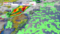
The greatest chance for thunderstorms looks to be between 6 p.m. and 10 p.m. as a line of storms pushes east across the peninsula. Northern parts of Delmarva have the best chance to see a stronger storm. Damaging wind gusts over 60 mph and large hail would be the main threats.

Watching the chance for storms on Delmarva Wednesday evening, after 6PM, greatest chance would be northern portions of the peninsula.
A strong cold front will cross Delmarva late Wednesday night into Thursday morning. Showers and thunderstorms may accompany the front, although the overnight timing could limit how widespread severe weather becomes. Even so, the atmosphere will remain mild and moist enough ahead of the front for a few stronger storms to be possible, especially if storms arriving from the west hold together.
Once the front clears Thursday morning, much colder air will rush in. Temperatures are expected to peak just after midnight, then fall steadily through the 50s during the morning and into the 40s by late afternoon. Scattered showers and a few wet snow flakes are possible late Thursday. Strong northwest winds will add to the chill, bringing a sharp end to Delmarva’s early taste of spring.
The weekend looks seasonable and pleasant with highs in the 50s and 60s, turns even colder for St. Patrick's Day with highs stuck in the 30s and 40s.
