




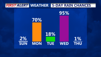
Today will see a warm-up, with temperatures climbing 10 to 15 degrees higher than Saturday, reaching the mid-to-upper 50s under mostly sunny skies. A warm front will bring increased moisture and cloud cover Sunday night. Rain is expected Monday and midweek as a strong cold front moves through, followed by colder, drier conditions Thursday and Friday.
From
To


The Delmarva Peninsula will experience cooler temperatures, gusty northwest winds, and periods of rain Thursday into Friday as a slow-moving low-pressure system meanders near the region. Rainfall will gradually taper off by Friday evening, but breezy, raw conditions will persist.

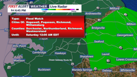
Heavy showers and thunderstorms are expected to intensify over Delmarva starting overnight, with significant rainfall and potential flash flooding through Saturday afternoon.
A stalled frontal boundary near the I-95 corridor will influence weather conditions on the Delmarva Peninsula over the short term, bringing periods of rain and potential flash flooding.