


DELMARVA - Additional forcing for ascent is forecast to arrive overnight, which will intensify and expand the showers (with some thunder) north and westward.
A front has lifted northward into the area from the coast. Bermuda high pressure will continue to advect a ribbon of rich tropical moisture back into the region along and south of this front. Meanwhile, a broad jet located to our northeast will result in broad diffluence aloft, strengthening through Saturday. Additionally, a closed upper low is passing by just offshore.
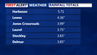
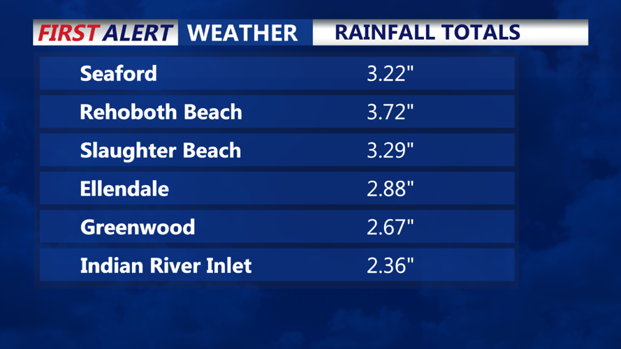
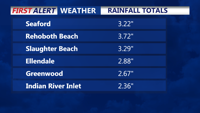
The heaviest rain has occurred near the coast, which was farther south than anticipated for the daytime period. Localized amounts of 3-5" of rainfall have been observed. Precipitable water values (PWats) will remain around 2-2.5", near climatological maxima, along with MUCAPE near 1,000 J/kg. The more robust showers and thunderstorms that develop will be capable of producing very heavy rainfall, with rainfall rates near 2" per hour. The threat of severe thunderstorms is very low.
With all the cloud cover and moisture around tonight, temperatures will remain quite mild, with lows ranging from the low to mid 70s. Light southerly winds are expected through Saturday, though winds will become light and variable at times.
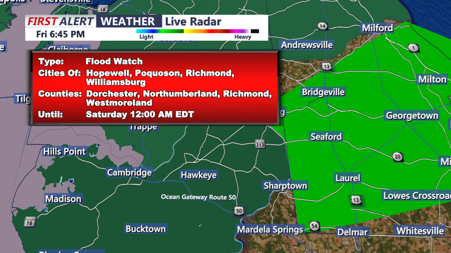
While the heaviest rainfall so far today has occurred near the coast, guidance continues to pinpoint the heaviest rainfall potential from across portions of Delmarva and into the urban corridor through early Saturday afternoon. An additional wave of widespread heavy showers and thunderstorms is expected to impact this area beginning around daybreak Saturday through around midday. Widespread rainfall amounts near 1-2" can be expected, with locally higher amounts up to 5" possible. Rainfall rates may exceed 1-2" per hour at times. While much of the area has been dry recently, the rainfall rates may lead to some areas of flash flooding, especially in urbanized and poor drainage areas. The Flood Watch remains in effect as previously issued through 2 PM Saturday to highlight this threat.