


Blustery winds and cooler-than-normal temperatures will dominate Tuesday and Wednesday, with scattered showers and a risk of small hail in parts of the region.
From
To

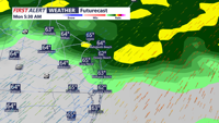
A pair of cold fronts will bring breezy conditions, cooler temperatures, and dry weather to Delmarva from Monday morning through Tuesday morning, with a sharp drop in temperatures overnight into Tuesday.

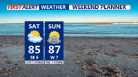
A primary cold front will approach the Delmarva Peninsula on Saturday, bringing warmer and muggier conditions by the afternoon as the flow turns southerly. Expect high temperatures in the low to mid-80s with mainly dry weather during the day, but showers and thunderstorms are likely after 8 PM as the front moves in. Additional unsettled weather is anticipated from Sunday with a marginal risk for severe storms. High pressure will bring drier conditions for the first half of the upcoming week.

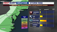
Delmarva will experience the passage of a cold front, bringing the potential for showers and isolated severe storms. Damaging winds are the primary threat, but the storms will be shorter and weaker than those seen on Sunday. Expect a significant drop in dew points and a shift to cooler, more comfortable air by tomorrow morning, with highs in the 70s and lows in the 50s. Dry, tranquil weather will continue through the rest of the week, with a secondary cold front on Tuesday night leading to even lower dew points and autumn-like temperatures.