


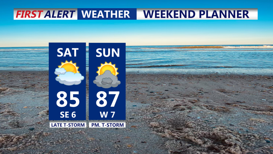


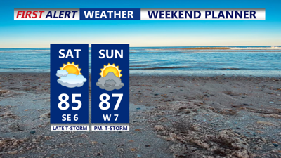
DELMARVA -- A fairly pronounced primary cold front will approach the Delmarva region from the northwest on Saturday. This will shift winds to a southerly direction by late morning, helping to mix out the marine layer and clear low clouds by the afternoon. As a result, the coastal plain will see the most sunshine, with high temperatures reaching the low to mid-80s. Conditions will remain warm and muggy throughout the afternoon, but most of the area is expected to stay dry during the daytime hours.
There is a MODERATE risk for rip currents so keep them in mind when venturing into the ocean this weekend. Pay close attention to the lifeguards always.
The chances for showers and thunderstorms will increase after 8 PM as the cold front moves closer. While the threat of severe weather is low, there remains the potential for isolated thunderstorms with periods of moderate to heavy rainfall, especially with precipitable water values approaching 2 inches. The strongest storms are expected to remain further north in eastern Pennsylvania and northern New Jersey, where there is a Slight Risk for severe thunderstorms.
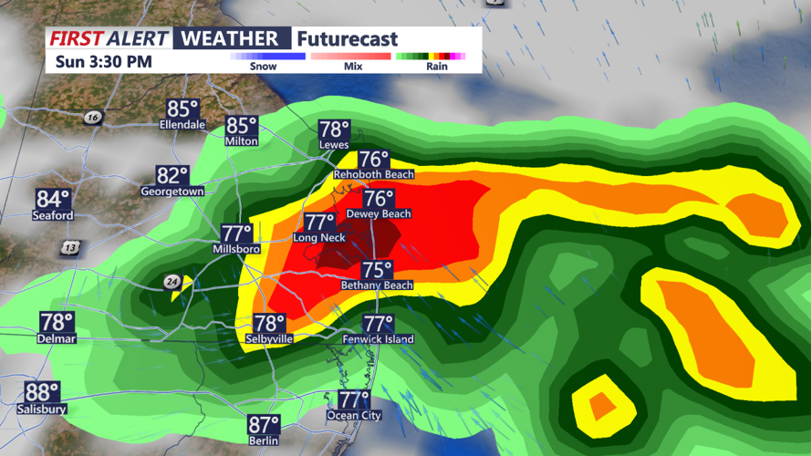
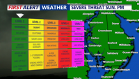
The unsettled weather pattern is expected to persist from Saturday night through Sunday night as two cold fronts impact the area. The first front will move across Delmarva on Saturday night. Although the timing of the front should limit severe weather and heavy rainfall, isolated thunderstorms are still possible. The instability that builds to our west during the day is likely to decrease as the front progresses eastward, leading to weakening storms by the time they reach our area.

On Sunday, the initial front may slow down or stall near the region, allowing for additional showers and isolated thunderstorms, though coverage is not expected to be widespread. A secondary cold front will move through Sunday night, maintaining a marginal risk (1 out of 5) of severe thunderstorms across the area.

As we move into the extended forecast, much of the Delmarva region is expected to see drier conditions as high pressure builds in from the Great Lakes.
Labor Day will be fantastic, sunshine, breezy and dry with lower humidity levels. Highs will be in the upper 70s to around the low 80s.
By Tuesday and Wednesday, conditions will become less windy as high pressure settles directly over the Northeast and Mid-Atlantic states, leading to dry and pleasant weather.
Uncertainty increases towards the end of the week as another cold front approaches from the west and a possible low pressure system lifts northward from the south. Current models show varying scenarios, but there's a chance of precipitation on Friday into Saturday due to these approaching systems.
