


The sun returns today, but it stays on the chilly and breezy side.
From
To

Delmarva started the day with a cold morning, with many spots away from the coast in the 20s, but sunshine and lighter winds will help temperatures recover into the mid to upper 50s and near 60 this afternoon. Milder air builds in tonight and Wednesday, with highs surging into the upper 60s and low 70s. Even warmer weather arrives Thursday and Friday before a cooler pattern and the chance for beneficial widespread rain return this weekend.


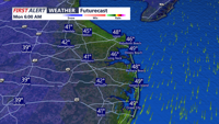
This afternoon, we'll see a mix of sun and clouds, with breezy and cool conditions. Northwest winds will gust 25 to 35 mph at times.


Bright sunshine across Delmarva, but temperatures will struggle to climb out of the 40s for many areas, with only some low 50s on the Mid-Shore. Winds out of the east northeast at 10 to 20 mph will add to the cool feel. Another cold night follows tonight with lows dropping into the low to mid 30s, and frost will be possible by Thursday morning. Conditions stay dry through the rest of the week as strong Canadian high pressure remains in control. Temperatures begin to moderate Thursday into the upper 50s to near 60, then turn even milder Friday.

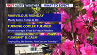
Delmarva will enjoy plenty of sunshine Monday with highs in the upper 50s to near 60, but breezy west-northwest winds will keep it feeling cool. A reinforcing shot of cold air arrives Tuesday, bringing gusty winds, elevated fire concerns, and a growing risk of freezing temperatures by Wednesday morning, with patchy frost possible again Thursday.

The rest of Saturday will be bright, but blustery across Delmarva, with wall-to-wall sunshine.


Sussex County, Delaware, is expected to see a breezy late Friday night followed by a sunnier, much windier and drier Saturday, with gusts potentially reaching 30 to 40 mph.

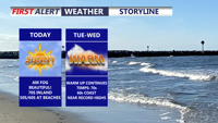
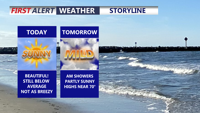
Today brings sunshine and unseasonably warm weather across Delmarva, with inland temperatures rising into the upper 60s and low 70s, while areas along the Bay and beaches stay cooler in the 50s and 60s. More fog is expected tonight under mainly clear skies, with lows in the upper 40s inland and upper 40s to low 50s near the coast.


A cold early Wednesday in Sussex County rebounds to the low-to-mid 40s with sunshine, then turns chilly again overnight into early Thursday.

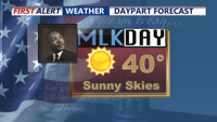
A sunny and chilly MLK Day, then back into the deep freeze.