


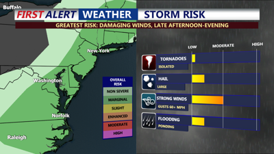
DELMARVA - High risk of rip currents continue. Be mindful we once again will be dealing with high surf and beach erosion. Pay close attention to the lifeguards. This afternoon and into the early evening, Delmarva will feel the effects of a cold front pushing through the region. As the front moves across I-95 and areas north and west, the heating of the day will help trigger another round of showers and thunderstorms. However, these storms are expected to be weaker and more fleeting than those seen on Sunday, thanks to faster-moving air aloft ahead of an incoming shortwave trough. While the flood risk is minimal and no flood watches are in effect, isolated severe storms could develop, with damaging winds being the primary concern. High temperatures will range from the mid to upper-80s inland, to upper 70s to low 80s at the coast.
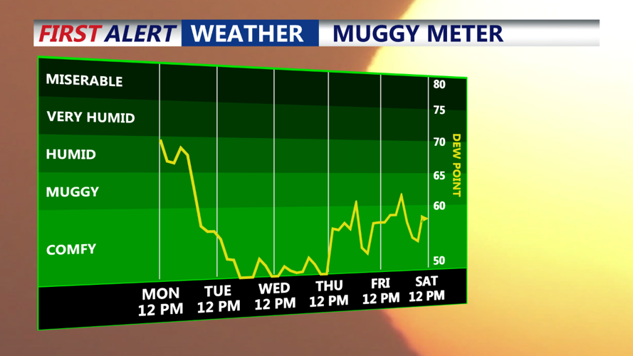
As the front passes this evening, the threat of thunderstorms will quickly diminish, along with a noticeable drop in dew points. By tomorrow morning, residents can expect a refreshing northwesterly breeze and much drier, more comfortable air. Overnight lows will dip into the 50s to lower 60s, providing a cool start to Tuesday.

Tuesday will bring a welcome change as the initial cold front moves out, leaving behind a drier and cooler airmass. Highs in the 70s across Delmarva. A secondary cold front will move through late Tuesday, bringing an additional push of dry air that will drop dew points to their lowest levels of the summer, falling into the mid to upper 40s.
Wednesday will be another cool and comfortable day, with high pressure building in from the west. Expect more sunshine than clouds, with high temperatures similar to Tuesday's, but with even more pleasant conditions. Overnight lows will again fall into the lower to mid-50s, with coastal areas staying closer to 60 degrees, making it feel more like late September rather than late August.
The extended forecast remains unchanged, with high pressure dominating the region on Thursday and Friday before shifting southeastward over the weekend. Delmarva will stay under the influence of a deep upper trough on Thursday, leading to continued cool and dry conditions. By Friday, the trough will lift, and upper-level heights will rise, signaling a return to more seasonable temperatures by the weekend, with the potential for above-normal warmth.
Overall, Delmarva can look forward to a stretch of tranquil and dry weather, a welcome relief after the unsettled conditions of the past few days.
