


After days of relentless thunderstorms dumping more than six inches of rain since the beginning of the month across parts of Sussex County, we are enjoying a quieter weekend. However, patchy fog and muggy nights will persist, and a cold front approaching early next week may renew the threat of showers and thunderstorms.
From
To

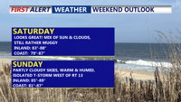
A persistent warm and muggy pattern will continue over Delmarva through early next week, bringing periods of low clouds and patchy fog overnight, with daytime highs in the 80s. While the weekend should remain mostly dry aside from isolated inland storms, a cold front approaching Monday will trigger more widespread showers and thunderstorms. Temperatures will stay above normal into midweek, with heat indices nearing 100 degrees in some locations.

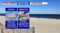
A stalled front lingering over the Delmarva Peninsula will keep the region humid through the weekend, with occasional showers and storms. Although conditions will ease somewhat compared to midweek, isolated flash flooding and strong wind gusts remain possible. A stronger cold front will arrive early next week, bringing more widespread storms and a gradual drying trend.

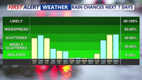
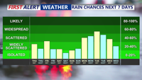
Sussex County will experience scattered showers, thunderstorms, and rising temperatures through Saturday, with the potential for gusty winds and heavy downpours.