


DELMARVA -- Saturday night marks a welcome break in the stormy pattern that has soaked Delmarva in recent days.

This month has yielded some heavy isolated rainfall totals, especially for the southeastern portion of Sussex County.
Communities from Fenwick Island to Indian River Inlet have measured more than six inches of rainfall, primarily from sea breeze–driven thunderstorms. Dewey Beach and Rehoboth Beach tallied between two and two and a half inches, while central Sussex County picked up closer to three or four inches. Farther north into Milford and southern Kent County, totals tapered off somewhat but remained above normal for mid-July.
Tonight, conditions will stay humid and unsettled. Fog is expected to redevelop along the coast, accompanied by low clouds and patchy mist. Temperatures will remain mild, with lows settling in the low to mid-70s across the peninsula.

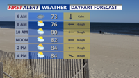
Start Sunday with some areas of fog, highs in the mid to upper 80s.
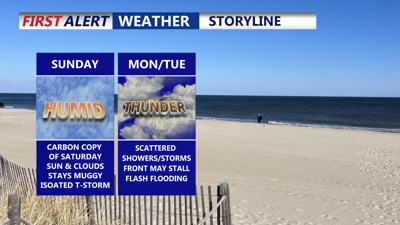
Sunday’s forecast offers more of the same summer humidity but relatively quiet skies for most. Highs in the low to mid-80s along the beaches and the upper 80s inland.

Some morning fog/low clouds, give way to sunshine in the afternoon.
While an isolated thunderstorm can’t be ruled out over the Eastern Shore, most areas should remain dry through the daylight hours as shower chances stay farther north and west.
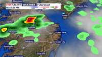
The reprieve will be short-lived. A sluggish cold front approaching from the west is set to edge into the region late Sunday night into Monday. As it creeps forward, showers and thunderstorms will redevelop, especially across the western half of the area by early Monday. Depending on how quickly the front advances, some showers could linger through the Monday morning commute. Another round of rain and storms is likely Monday afternoon into Monday night, as the front sags slowly toward the coast.

Cold front arrives Monday, bring scattered showers and storms to the peninsula.
Looking ahead to the middle of the week, showery pattern is likely to persist. The front is expected to stall nearby or over the region into Tuesday and Wednesday before lifting back north as a warm front by Thursday. As this boundary meanders, chances for scattered thunderstorms will continue each afternoon, with the heaviest activity possible where daytime heating combines with lingering moisture.
By late in the week, we can see temperatures rise into the low 90s with heat indices over 100, Thursday and Friday with daily isolated thunderstorm chances.