


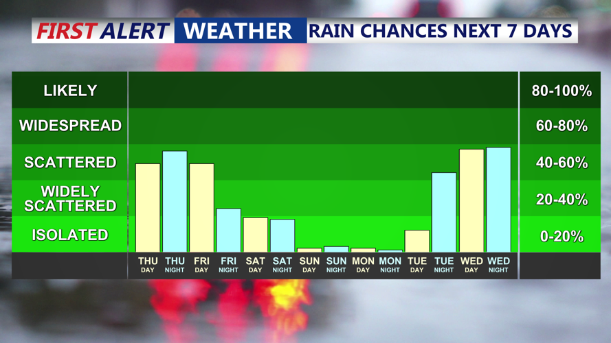


DELMARVA - A brief period of quieter weather is expected Thursday night as high pressure briefly moves over the area. Skies may partially clear, and patchy fog could develop overnight, though not as dense as previous mornings. Overnight lows will be mild, ranging from the upper 50s to low 60s.
Friday:
A warm front will lift through the region early Friday, bringing scattered showers and possibly a decaying thunderstorm complex in the morning. While severe weather is not expected, the area will become increasingly warm and humid, with highs reaching the 80s. Scattered showers and a few thunderstorms are likely to redevelop by afternoon. Rain chances decrease overnight, but light sprinkles may linger.
Saturday:
Saturday is the day to watch closely. A more potent system approaches from the Great Lakes, bringing stronger atmospheric forcing and an advancing cold front. High temperatures will again reach the 80s, and humidity will be high. Showers and thunderstorms are expected in the afternoon and evening, with a risk of damaging wind gusts and heavy rainfall. The potential for severe weather exists, although confidence in the exact timing and intensity is still developing.
Looking Ahead:
Conditions improve Sunday through Tuesday with drier, seasonable weather expected. Gusty winds may persist on Sunday with gusts near 30 MPH. Another rainmaker could impact the area midweek, though the track and timing remain uncertain.