


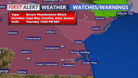
A Severe Thunderstorm Watch in place for all of Delaware until 10 p.m. Storms could produce damaging winds and hail. Coastal flooding is also a concern in Sussex County, where up to a foot of water may impact tidal roads and back bays due to an onshore flow and new moon. After the storms, a complex frontal pattern sets up through early next week, bringing shifting temperatures, intermittent rain chances, and elevated humidity levels before high pressure returns by midweek.
From
To


Delmarva faces an intense burst of summer weather beginning Wednesday, with highs soaring into the 90s and heat indices nearing 100 degrees. Widespread thunderstorms—some potentially severe—are likely late Thursday. A cold front will usher in more comfortable, drier air for the weekend, though hot temperatures return early next week.


Sussex County faces a stretch of hot, humid weather with the threat of strong to severe thunderstorms Wednesday and Thursday ahead of a cooling trend by Friday.


Rain and breezy conditions arrive in Sussex County Thursday night through Friday, with improving weather by Saturday.


A warmer day is expected to start the week, with highs in the 60s. A cold front tonight will trigger showers and storms overnight, some could be marginally severe with damaging winds possible. Cooler and drier for Tuesday.