


DELMARVA - A slow-moving warm front is making its way northward across the region, signaling a return to summerlike heat and humidity across Sussex County through Thursday, with the added threat of strong to severe thunderstorms by midweek.
By Tuesday night, the warm front will hover near Delmarva, bringing patchy fog, drizzle, and a chance for isolated showers. Overnight lows will remain muggy, falling only to the mid-60s to low 70s. Fog could linger into the morning hours Wednesday before skies gradually clear.
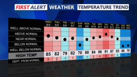
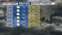
On Wednesday, temperatures will soar into the mid-80s to low 90s with tropical-like dew points in the 70s, creating heat indices near or exceeding 100 degrees. While official heat advisories are not issued for Sussex County, the region will still face oppressive conditions. Scattered thunderstorms are expected to pop up in the afternoon, particularly after 2 p.m., and may produce damaging wind gusts and heavy rainfall. The Storm Prediction Center places the region under a Marginal risk for severe weather.
By Thursday, a more organized system approaches. A cold front tied to a low-pressure system sweeping in from the Great Lakes is set to pass through the region late in the day. Highs will push even higher into the upper 80s to low 90s, with heat indices again reaching the mid to upper 90s across the Delmarva. Severe thunderstorms may erupt along and ahead of the front, especially between 4 p.m. and 10 p.m., with strong wind gusts and hail possible. CAPE values of 1500-2500 J/kg and deep-layer shear suggest a setup supportive of multiple damaging wind reports, and the National Weather Service warns that Thursday could be the most active severe day of the week.
Storms are expected to clear the coast by late Thursday night as the cold front pushes offshore. Cooler and drier air will filter in behind the front, setting the stage for a more comfortable Friday with sunshine, lower humidity, and highs in the 80s.
Looking ahead to the weekend and early next week, high pressure will dominate. While dry weather will prevail, temperatures will quickly rebound with mid to upper 90s possible by Monday and Tuesday inland. Heat indices could again exceed 100, except along the coast where sea breezes offer some relief.
