


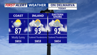


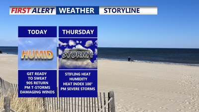
DELMARVA -- A steamy stretch of summer weather beginning Wednesday, as fog and mist give way to sun and surging temperatures. With a Bermuda high setting up offshore, the region will experience rapid warming, pushing highs into the 80s and even the low 90s—especially inland and away from coastal areas. Heat index will make it feel like the upper 90s to near 100. The Storm Prediction Center has a "marginal" risk (1 of 5) for the threat of some severe storms later this afternoon through the early evening. Some of those storms could bring a damaging wind threat. So stay weather aware through the evening.

Temperatures in the upper 80s to low 90s, feeling more like 95-100 with the heat index, some storms late today could pose a damaging wind threat.
As the storms end this evening will be partly cloudy and muggy overnight, with patchy fog and mild lows in the mid 70s.
Humidity levels will climb even more into Thursday, making it feel even hotter. Heat indices are forecast to reach between 95 and 100 degrees, prompting caution for those spending extended time outdoors. The sweltering conditions come as southwesterly winds funnel in moisture ahead of an approaching cold front.

Heat indices approaching triple digits Wednesday & Thursday.
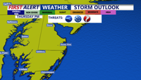
By Thursday afternoon and evening, this front will be the trigger for potentially strong to severe thunderstorms. Storms are expected to develop across western Delmarva in the afternoon and track eastward into the evening. The Storm Prediction Center places the region under a "slight" risk (2 of 5) for severe weather, with strong downdraft winds being the primary concern. Isolated tornado is possible, with hail and localized heavy rainfall are also possible.

Greater threat for severe storms late Thursday afternoon-evening, storms could pack damaging winds, hail and an isolated tornado.
Atmospheric conditions—including high moisture and instability—are ripe for efficient rainfall production. While widespread flooding is not expected, urban and low-lying areas could see brief localized flooding where storms hit hardest.
After the storms clear Thursday night, skies will gradually clear and winds will shift out of the northwest. Overnight lows will dip into the mid to upper 60s, bringing a brief break from the oppressive heat.

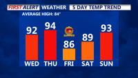
Above average temperatures, Sunday will be the start of our first heatwave of the year.
Looking ahead to Friday and the weekend, high pressure will take control, delivering mostly sunny skies and lower humidity. Daytime highs will remain warm—in the low to mid 80s—but with much more comfortable conditions.
However, the relief will be short-lived. A sprawling ridge is expected to build over the East Coast early next week, sending temperatures soaring once again. By Monday and Tuesday, much of Delmarva could see highs in the mid to upper 90s, with heat indices exceeding 100. Only coastal areas are likely to remain cooler.