


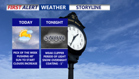
Today is the best day of the week across Delmarva, with highs in the upper 30s to low 40s before clouds thicken late. A weak clipper brings a quick hit of light snow after midnight, ending by daybreak Wednesday with an inch or less. The bigger story late week into the weekend is a surge of Arctic air—dangerously cold wind chills and another round of light snow or snow squalls possible Friday.
From
To

Residents in Sussex County and the southern half of the Delmarva Peninsula can expect a chilly and mostly calm Christmas Eve and Day, with minor weather disturbances clearing out tonight and high pressure bringing mostly sunny skies for the holiday.

Delmarva will face frigid temperatures as an Arctic high-pressure system brings some of the coldest weather in years. Lows may dip into the single digits Sunday night, with daytime highs struggling to rise above the upper 20s to low 30s. A weak system could bring light snow or rain showers late Monday into Christmas Eve, followed by moderating temperatures heading into the holiday weekend.

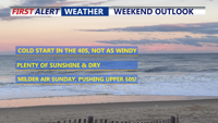
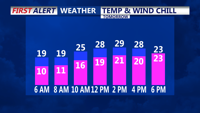
Delmarva will remain under the grip of cold weather tonight as high pressure builds from the southeast. Winds will calm through the overnight. Temperatures will drop into the 20s. . The weekend brings a gradual shift to milder weather, although increasing cloud cover may temper daytime highs. Rain chances increase early to middle of next week.