


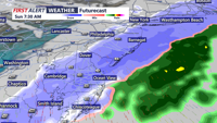
Snow is expected to develop early Sunday morning and continue through late Sunday morning. Accumulations are expected to be in the 1-3" range, with slick roads Sunday morning.
From
To

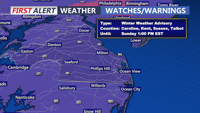
Snow is expected to develop early Sunday morning and continue through late Sunday morning. Accumulations are expected to be in the 1-3" range, with slick roads Sunday morning.

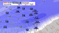
Snow is expected to develop early Sunday morning and continue through late Sunday morning. Accumulations are expected to be in the 1-3" range, with slick roads Sunday morning.

Current forecasts call for widespread snowfall totals of 1 to 3 inches, with localized amounts up to 4 inches possible, primarily north of Kent County, DE.


Another round of accumulating snow is expected early Sunday, then a blast of bitter cold weather into early next week.


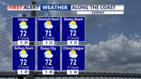
A dry and milder start to the weekend, then morning snow on Sunday, followed by the coldest airmass of the season so far.


A cloudier end to the weekend with Sunday showers, then a coastal low brings a cold rain on Tuesday with a Yellow Alert.

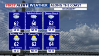
A coastal system develops off the Carolinas, sliding northeast and moving offshore. Another low pressure system will form to the south, passing near or just west of Delmarva by Thursday night, pushing a cold front through the region.

DELMARVA- High pressure continues to slide off the coast today, ushering in warmer air and breezy conditions. A Yellow Alert is in effect for …


High pressure continues to slide off the coast overnight into Sunday, ushering in warmer air and breezy conditions. A Yellow Alert is in effect for Monday morning for strong winds and heavy rain.