


DELMARVA - pleasant and comfortable conditions this past weekend are coming to an end as humidity will be on the rise. Daily storm chances will increase all thanks to a series of frontal boundaries as we push through the week.
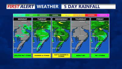
It's a pleasant and dry start to the last week of July. Temperatures will rise from the upper 60s to low 70s to the mid to upper 80s Monday afternoon. A southwesterly flow returns which means humidity levels will be creeping back up. Look for a mix of sun and clouds, hazy at times due to wild fire smoke. The smoke will not pose any threat to those with sensitive breathing conditions, can't rule out and isolated shower or thunderstorm as an area of low pressure well off the coast may throw a shower or two over towards Delmarva. However, most of the area should remain rain free.
Overnight Monday, an area of showers and storms are possible into early Tuesday morning. Will see partly sunny skies Tuesday, muggy, with highs in the mid 80s. Scattered showers and storms are likely by Tuesday afternoon.
It does look like Wednesday will feature the best chance of scattered showers and storm coverage over the Delmarva peninsula, as we can see a wave of activity move through during the morning and then another later in the day. It will be very tropical-like nonetheless, highs will be in the mid 80s.
By the end of the week we could be looking at the start of another heatwave with temperatures getting back up into the low 90s and heat indices back over 100 Thursday and Friday.