


DELMARVA- We're looking at another round of snow for Friday, prompting a First Alert Weather Day for the region.
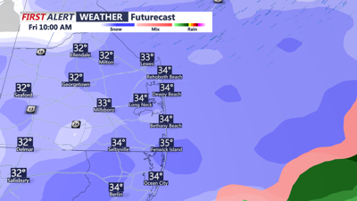
It appears the snow develops from the southwest to northeast between 5 a.m. to 7 a.m. Friday morning. Temperatures will be around freezing in the morning hours, which could cause slick roads and sidewalks. As temperatures rise above freezing we'll see the icy conditions ease a bit during the day.
Areas south of Route 9 will see snow that could mix with or change to rain, especially along the coast. The rain could keep accumulations down a bit in that area. Farther north we'll see mainly snow, with a little bit of rain mixing in at times.

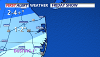
We're looking at 1-2" of snow across Sussex county on Friday. More to the north and less to the south.
Accumulations of 1 to 2 inches are expected across much of Sussex County, with higher amounts to the north of Route 9 where 2 to 4 inches or more could fall. Farther south across far southern Delaware and northern Maryland we could see a trace to 1 inch of snow. Lesser amounts due to more rain than snow during the storm.
Much colder air follows the storm resulting in a very cold weekend with single digit wind chills at times.