


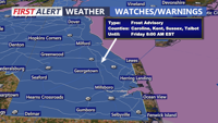
A stretch of tranquil but chilly weather is on tap for Delmarva as high pressure dominates through the end of the week. A frost advisory is in effect overnight for parts of the peninsula before temperatures rebound heading into the weekend. Another strong cold front is expected late Sunday, ushering in the coldest air of the season early next week.
From
To

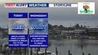
High pressure gives way to an approaching cold front tonight, bringing a fall-like airmass into Delmarva. While rain isn’t expected, breezy coastal winds and cooler-than-average temperatures will mark the midweek forecast before a warm-up this weekend.

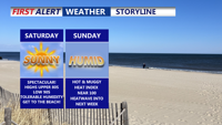
Sussex County will enjoy a brief reprieve from the heat Friday night into Saturday, but steamy conditions and dangerous heat index values are expected to return by Sunday and continue into early next week.

A strong cold front is expected to move through Delmarva late Monday, bringing the potential for strong to severe thunderstorms, heavy rainfall, and localized flooding. The worst of the weather is expected between 8 p.m. and 3 a.m. Tuesday. Cooler and drier conditions return Tuesday, but unsettled weather is likely to end the week.

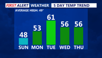
We can continue to look forward to a dry, pleasant weekend beginning Saturday night with mild temperatures and partly cloudy skies. Sunday promises seasonable, mostly sunny conditions, while a gradual warming trend kicks in early next week with highs climbing into the 50s and 60s. Later in the week, a stronger cold front brings our best chance for rain on Thursday before a cooler Canadian air mass returns Friday.