


Strong northwest winds and a cooler air mass make Thursday feel sharply colder, with cold, mainly dry conditions lasting into early Friday morning.
From
To


Sussex County faces a sharp drop in temperatures late Sunday into Monday, with road conditions likely impacted by gusty winds and freezing wind chills as an arctic front ushers in a Canadian high-pressure system.

High pressure will bring cold, calm weather to Sussex County Thursday night into Friday, with lows dipping into the upper teens inland. Friday will remain sunny but cold, with highs struggling to reach the low 40s in southern Delaware.

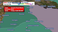
A Coastal Flood Advisory is in place from late Tuesday evening through Wednesday as gusty winds and cold air dominate the region. High pressure will maintain dry and sunny conditions through midweek, but freezing temperatures inland and elevated fire weather risks are concerns.


A cool and breezy weekend as high pressure builds over the region. Today will bring gusty northwest winds, with temperatures peaking in the upper 60s to near 70 degrees. A colder air mass moves in by Sunday, with daytime highs struggling to reach 60 degrees and widespread frost likely by Sunday night. The upcoming week will see a warming trend, with temperatures potentially reaching near-record highs by midweek under continued dry conditions.